forestatrisk Python package


![]()
![]()
![]()

Overview
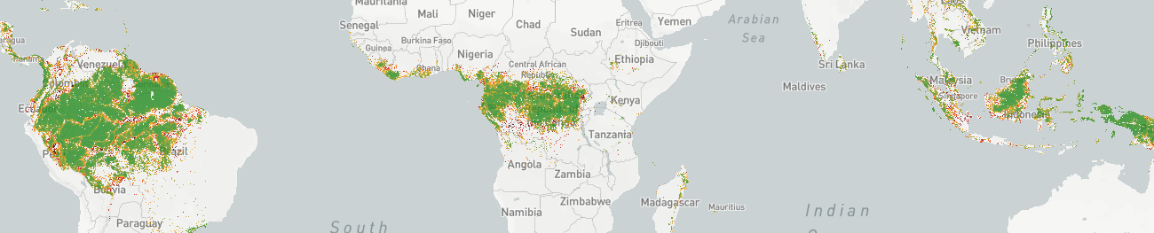
The forestatrisk Python package can be used to model the
tropical deforestation spatially, predict the spatial risk of
deforestation, and forecast the future forest cover in the
tropics. It provides functions to estimate the spatial probability of
deforestation as a function of various spatial explanatory variables.
Spatial explanatory variables can be derived from topography (altitude, slope, and aspect), accessibility (distance to roads, towns, and forest edge), deforestation history (distance to previous deforestation), or land conservation status (eg. protected area) for example.
Scientific publication
Vieilledent G. 2021. forestatrisk: a Python package for
modelling and forecasting deforestation in the tropics.
Journal of Open Source Software. 6(59): 2975.
[doi: 10.21105/joss.02975]. ![]()
Statement of Need
Spatial modelling of the deforestation allows identifying the main factors determining the spatial risk of deforestation and quantifying their relative effects. Forecasting forest cover change is paramount as it allows anticipating the consequences of deforestation (in terms of carbon emissions or biodiversity loss) under various technological, political and socio-economic scenarios, and informs decision makers accordingly. Because both biodiversity and carbon vary greatly in space, it is necessary to provide spatial forecasts of forest cover change to properly quantify biodiversity loss and carbon emissions associated with future deforestation.
The forestatrisk Python package can be used to model the tropical
deforestation spatially, predict the spatial risk of deforestation,
and forecast the future forest cover in the tropics. The spatial data
used to model deforestation come from georeferenced raster files,
which can be very large (several gigabytes). The functions available
in the forestatrisk package process large rasters by blocks of
data, making calculations fast and efficient. This allows
deforestation to be modeled over large geographic areas (e.g. at the
scale of a country) and at high spatial resolution
(eg. ≤ 30 m). The forestatrisk package offers the possibility
of using logistic regression with auto-correlated spatial random
effects to model the deforestation process. The spatial random effects
make possible to structure the residual spatial variability of the
deforestation process, not explained by the variables of the model and
often very large. In addition to these new features, the
forestatrisk Python package is open source (GPLv3 license),
cross-platform, scriptable (via Python), user-friendly (functions
provided with full documentation and examples), and easily extendable
(with additional statistical models for example). The forestatrisk
Python package has been used to model deforestation and predict future
forest cover by 2100 across the humid tropics
(https://forestatrisk.cirad.fr).
Installation
You will need several dependencies to run the forestatrisk Python
package. The best way to install the package is to create a Python
virtual environment, either through conda (recommended) or virtualenv.
Using virtualenv
The easiest way to install the forestatrisk Python package is via pip in the OSGeo4W Shell for Windows or in a virtual environment for Linux.
For Linux, create and activate a virtual environment before installing geefcc with pip:
cd ~
# Create a directory for virtual environments
mkdir venvs
# Create the virtual environment with venv
python3 -m venv ~/venvs/venv-geefcc
# Activate (start) the virtual environment
source ~/venvs/venv-geefcc/bin/activate
Install Python dependencies and forestatrisk in the OSGeo4W Shell or in the newly created virtual environment:
# Upgrade pip, setuptools, and wheel
python3 -m pip install --upgrade pip setuptools wheel
# Install numpy
python3 -m numpy
# Install gdal Python bindings (the correct version)
python3 -m pip install gdal==$(gdal-config --version)
# Install forestatrisk. This will install all other dependencies
python3 -m pip install forestatrisk
If you want to install the development version of forestatrisk, replace the last line with:
python3 -m pip install https://github.com/ghislainv/forestatrisk/archive/master.zip
To deactivate and delete the virtual environment:
deactivate
rm -R ~/venvs/venv-forestatrisk # Just remove the repository
In case of problem while installing GDAL Python bindings, try the following command:
python3 -m pip install --no-cache-dir --force-reinstall gdal==$(gdal-config --version)
Using conda
You first need to have miniconda3 installed (see here).
Then, create a conda environment (details here)
and install the forestatrisk package with the following commands:
conda create --name conda-far -c conda-forge python gdal numpy matplotlib pandas patsy pip statsmodels earthengine-api --yes
conda activate conda-far
pip install pywdpa scikit-learn # Packages not available with conda
pip install forestatrisk # For PyPI version
# pip install https://github.com/ghislainv/forestatrisk/archive/master.zip # For GitHub dev version
# conda install -c conda-forge python-dotenv --yes  # Additional libraries if needed
To deactivate and delete the conda environment:
conda deactivate
conda env remove --name conda-far
Installation testing
You can test that the package has been correctly installed using the
command forestatrisk in a terminal:
forestatrisk
This should return a short description of the forestatrisk package
and the version number:
# forestatrisk: modelling and forecasting deforestation in the tropics.
# https://ecology.ghislainv.fr/forestatrisk/
# forestatrisk version x.x.
You can also test the package following the Get started tutorial.
Main functionalities
Sample
Function .sample() sample observations points from a forest cover
change map. The sample is balanced and stratified between deforested
and non-deforested pixels. The function also retrieves information
from explanatory variables for each sampled point. Sampling is done by
block to allow computation on large study areas (e.g. country or
continental scale) with a high spatial resolution (e.g. 30m).
Model
Function .model_binomial_iCAR() can be used to fit the
deforestation model. A linear Binomial logistic regression model is
used in this case. The model includes an intrinsic Conditional
Autoregressive (iCAR) process to account for the spatial
autocorrelation of the observations. Parameter inference is done in a
hierarchical Bayesian framework. The function calls a Gibbs sampler
with a Metropolis algorithm written in pure C code to reduce
computation time.
Other models (such as a simple GLM or a Random Forest model) can also be used.
Predict and project
Function .predict() allows predicting the deforestation
probability on the whole study area using the deforestation model
fitted with .model_*() functions. The prediction is done by block
to allow the computation on large study areas (e.g. country or
continental scale) with a high spatial resolution (e.g. 30m).
Function .deforest() predicts the future forest cover map based on a
raster of probability of deforestation (rescaled from 1 to 65535),
which is obtained from function .predict(), and an area (in
hectares) to be deforested.
Validate
A set of functions (eg. .cross_validation() or
.map_accuracy()) is also provided to perform model and map
validation.
Contributing
The forestatrisk Python package is Open Source and released under
the GNU GPL version 3 license. Anybody
who is interested can contribute to the package development following
our Community guidelines. Every
contributor must agree to follow the project’s Code of conduct.