Get started
Overview
The pywdpa Python package is an interface to the World Database on Protected Areas (WDPA) hosted on the Protected planet website: https://www.protectedplanet.net. It allows users to download spatial shapefiles of protected areas (PA) for world countries using the Protected Planet API (https://api.protectedplanet.net).
This package contains two main functions:
Installation
You will need several dependencies to run the pywdpa Python package (numpy, gdal, and requests). The best way to install the package is to create a Python virtual environment, either through virtualenv or conda. A virtual environment is a self-contained directory tree that contains a Python installation for a particular version of Python, plus a number of additional packages.
Using virtualenv
You first need to have the virtualenv package installed (see here).
Then, create a virtual environment and install the pywdpa package with the following commands:
# In a shell
cd ~
mkdir venvs # Directory for virtual environments
cd venvs
virtualenv --python=/usr/bin/python3 venv-pywppa
source ~/venvs/venv-far/bin/activate
pip install pywdpa # For PyPI version, this will install all other dependencies
# pip install https://github.com/ghislainv/pywdpa/archive/master.zip # For GitHub dev version
# pip install geopandas descartes folium python-dotenv # Optional additional packages
To deactivate and delete the virtual environment:
deactivate
rm -R ~/venvs/venv-pywdpa # Just remove the repository
Using conda
You first need to have miniconda3 installed (see here).
Then, create a conda environment (details here) and install the pywdpa package with the following commands:
# In a shell
conda create --name conda-pywdpa python pip numpy gdal requests --yes
conda activate conda-far
# conda install geopandas --yes  # Optional additional packages available in conda
# conda install -c conda-forge descartes folium python-dotenv --yes  # Optional additional packages available in conda
pip install pywdpa # Install PyPI version
# pip install https://github.com/ghislainv/pywdpa/archive/master.zip # For GitHub dev version
To deactivate and delete the conda environment:
conda deactivate
conda env remove --name conda-pywdpa
Managing the WDPA API token
This package uses the Protected Planet API to access data on world protected areas. You must first have obtained a Personal API Token by filling in the form available at https://api.protectedplanet.net/request. Then you need to set an environment variable (we recommend using the name WDPA_KEY) using either the command os.environ["WDPA_KEY"]="your_token" or python-dotenv.
The validity of your token can be checked with function .get_token().
# In Python
import os
import pywdpa

# Set WDPA_KEY
# (assuming that your token is "ca4703ffba6b9a26b2db73f78e56e088")
os.environ["WDPA_KEY"]="ca4703ffba6b9a26b2db73f78e56e088"

# Check your token validity
pywdpa.get_token()
If your token is valid, the function will return its value. Otherwise it will print an error message.
Downloading protected areas
The function .get_wdpa() can be used to download the shapefile of protected areas for the Reunion Island which has the iso code “REU”. The output file name in the working directory will be “pa_REU.shp”.
[1]:
import pywdpa

pywdpa.get_wdpa("REU")
The shapefile can be imported in the Python environment, for example using the Python package geopandas.
[2]:
import geopandas as gpd

pa_REU = gpd.read_file("pa_REU.shp")
pa_REU.head()
[2]:
| wdpa_id | pa_name | orig_name | ctry_iso3 | owner_type | is_marine | type | iucn_cat | status | date | geometry | |
|---|---|---|---|---|---|---|---|---|---|---|---|
| 0 | 62780 | Bois De Nèfles-Saint-Paul | Bois De Nèfles-Saint-Paul | REU | Not Reported | False | Forest Integral Biological Reserve | Ia | Designated | 01/01/1985 | POLYGON ((55.38600 -21.03200, 55.37700 -21.027... |
| 1 | 62786 | Hauts De Saint-Philippe | Hauts De Saint-Philippe | REU | Not Reported | False | Forest Integral Biological Reserve | Ia | Designated | 01/01/1987 | POLYGON ((55.72300 -21.33500, 55.71100 -21.337... |
| 2 | 62787 | Les Mares | Les Mares | REU | Not Reported | False | Forest Integral Biological Reserve | Ia | Designated | 01/01/1987 | POLYGON ((55.72300 -21.18300, 55.73900 -21.179... |
| 3 | 83081 | Bois Blanc | Bois Blanc | REU | Not Reported | False | Land Acquired By Conservatoire Du Littoral (Na... | IV | Designated | 01/01/1980 | MULTIPOLYGON (((55.80000 -21.19700, 55.81900 -... |
| 4 | 83112 | Grande Anse | Grande Anse | REU | Not Reported | True | Land Acquired By Conservatoire Du Littoral (Na... | IV | Designated | 01/01/1982 | MULTIPOLYGON (((55.54900 -21.36800, 55.54800 -... |
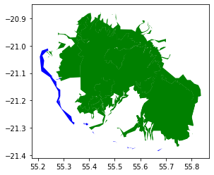
Protected areas can be plotted using either the .plot function from the geopandas object or using the Python package folium which makes it easy to visualize data that’s been manipulated in Python on an interactive leaflet map.
[3]:
from matplotlib.colors import ListedColormap
cm = ListedColormap(["green", "blue"])
pa_REU.plot(column="is_marine", cmap=cm)
[3]:
<matplotlib.axes._subplots.AxesSubplot at 0x7f534817dee0>
[4]:
import folium
latitude = -21.1
longitude = 55.5
fcol = lambda x: {
    'fillColor': "blue" if x["properties"]["is_marine"] == "True" else "green",
    'color': "blue" if x["properties"]["is_marine"] == "True" else "green"
}
m = folium.Map(location = [latitude, longitude],
               zoom_start = 10)
folium.GeoJson(pa_REU.to_json(), style_function=fcol).add_to(m)
m
[4]:
Command line
The function .get_wdpa() can be directly executed in a shell using the pywdpa command followed by the country iso code as argument. This will download the shapefile of the protected areas for the Reunion Island in the current working directory.
[5]:
%%bash
# In a shell
pywdpa REU
Executing pywdpa version 0.1.5.
For country with isocode: REU.